利用两期地表DEM数据计算工程土方量需要准许以下数据:
当前地图有3个图层,两个栅格图层和一个矢量图层
两个栅格图层:beforeDem为工程施工前的地表DEM模型
afterDem为工程施工后的地表DEM模型
一个矢量图层:pFeatureLayer
第一步生成掩膜:面转栅格 conversion.PolygonToRaster 生产名称为“poly”的栅格数据。
OID为pFeatureLayer的字段
pFeatureLayer = PMap.FindLayers(ComboBox4.Text).FirstOrDefaultIf pFeatureLayer IsNot Nothing ThenGoTo qqwwDim maskRaster As String = Path.Combine(Project.Current.DefaultGeodatabasePath, $"poly")va = Geoprocessing.MakeValueArray(pFeatureLayer, "OID", maskRaster) ' 直接传递环境参数列表Dim result = Await Geoprocessing.ExecuteToolAsync("PolygonToRaster_conversion", va)If result.IsFailed ThenThrow New Exception($"掩膜生成失败: {String.Join(vbCrLf, result.ErrorMessages)}")End If第二步生成掩膜:按掩膜提取分别生成两个栅格图层
before_clipped:为工程施工前的地表DEM的提取模型
after_clipped :为工程施工后的地表DEM的提取模型
Dim outputName As StringDim inputRaster As StringDim outputPath As StringDim envSettings = New List(Of KeyValuePair(Of String, Object))For i = 1 To 2If i = 1 Then inputRaster = beforeDem : outputName = "before_clipped"If i = 2 Then inputRaster = afterDem : outputName = "after_clipped"'直接传递环境参数列表envSettings = New List(Of KeyValuePair(Of String, Object)) From {New KeyValuePair(Of String, Object)("cellSize", "MAXOF"), New KeyValuePair(Of String, Object)("template", inputRaster)}outputPath = Path.Combine(Project.Current.DefaultGeodatabasePath, outputName)Dim extractParams = Geoprocessing.MakeValueArray(inputRaster, maskRaster, outputPath, "INSIDE")result = Await Geoprocessing.ExecuteToolAsync("ExtractByMask", extractParams) 'ExtractByMaskIf result.IsFailed ThenMsgBox(inputRaster & "栅格按掩膜提取失败")End IfNext第三步CutFill分析:执行CutFill分析,分析结果生成分析栅格数据CutFill_Result
'1. 裁剪DEM到指定范围Dim clippedBefore = Path.Combine(Project.Current.DefaultGeodatabasePath, "before_clipped")Dim clippedAfter = Path.Combine(Project.Current.DefaultGeodatabasePath, "after_clipped")'2. 执行CutFill分析outputName = "CutFill_Result"outputPath = System.IO.Path.Combine(Project.Current.DefaultGeodatabasePath, outputName)Dim parameters = Geoprocessing.MakeValueArray(clippedBefore, clippedAfter, outputPath, "METER")result = Await Geoprocessing.ExecuteToolAsync("CutFill", parameters)If result.IsFailed ThenThrow New Exception($"CutFill分析失败: {String.Join(vbCrLf, result.ErrorMessages)}")End If第四步分析成果按属性提取:ExtractByAttributes,提取的数据仍然为栅格数据
属性提取Where 子句使用 SQL 查询
"VOLUME < 0" 填方
"VOLUME > 0" 挖方
"VOLUME = 0" 未变化
输出栅格的属性表用于确定显示方式,并且分别将正体积和负体积视为挖出材料的位置(已移除)和填充材料的位置(已添加)。
' 计算挖方量
Dim cutParams = Geoprocessing.MakeValueArray(cutFillRasterPath, "VOLUME > 0", GeodaPath & "\WFMJ")    '按属性提取
gpResult = Await Geoprocessing.ExecuteToolAsync("ExtractByAttributes", cutParams)
If gpResult.IsFailed ThenMsgBox("挖方区域提取失败.")
End If' 计算填方量Dim fillParams = Geoprocessing.MakeValueArray(cutFillRasterPath, "VOLUME < 0", GeodaPath & "\" & "TFMJ")   '按属性提取gpResult = Await Geoprocessing.ExecuteToolAsync("ExtractByAttributes", fillParams)If gpResult.IsFailed ThenMsgBox("填方区域提取失败.")End If' 计算未变化方量Dim wbhParams = Geoprocessing.MakeValueArray(GeodaPath & "\" & cutFillRasterPath, "VOLUME = 0", GeodaPath & "\" & "WBHMJ")gpResult = Await Geoprocessing.ExecuteToolAsync("ExtractByAttributes_management", wbhParams)If gpResult.IsFailed ThenMsgBox("未变化区域提取失败.")End If
第五步获取栅格数据属性如:
- x 方向上的像元大小—x 方向上的像元大小。
- y 方向上的像元大小—y 方向上的像元大小。
va = Geoprocessing.MakeValueArray("TFMJ", {"CELLSIZEX", "CELLSIZEY"})gpResult = Await Geoprocessing.ExecuteToolAsync("management.GetRasterProperties", va)If gpResult.IsFailed ThenMsgBox("栅格数据属性提取失败.")End If第六步分析栅格数据属性表访问Attributes:
TryAwait QueuedTask.Run(Sub()' 获取栅格数据集Dim raster As Raster = rasterLayer.GetRaster()If raster Is Nothing Then Return' 正确检查属性表的方法Dim hasTable As Boolean = FalseTry' 尝试获取属性表Using table As Table = raster.GetAttributeTable()hasTable = True' 获取字段信息'Dim fields As IReadOnlyList(Of Field) = table.GetDefinition().GetFields()'Dim fieldNames As String = String.Join(", ", fields.Select(Function(f) f.Name))'MessageBox.Show($"找到属性表,包含字段: {fieldNames}")Dim tabrow = table.Search(Nothing, False)Do While tabrow.MoveNext'访问属性表 LoopEnd UsingCatch ex As Exception When TypeOf ex Is NotSupportedException OrElseTypeOf ex Is InvalidOperationException' 捕获不支持属性表的异常hasTable = FalseEnd TryIf Not hasTable ThenMessageBox.Show("该栅格没有属性表")End IfEnd Sub)Catch ex As ExceptionMessageBox.Show($"访问属性表时出错: {ex.Message}")End Try如果只需要计算方量,第四步、第五步可省略。
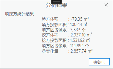
运行后,可得: